
Brooklyn, New York as seen from space!
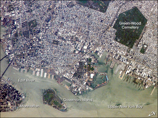
This astronaut photograph captures the dense urban fabric of Brooklyn, New York City's largest borough (population of 2.6 million), characterized by the regular pattern of highly reflective building rooftops (white). Two main arteries from Manhattan into Brooklyn--the famous Brooklyn Bridge and neighboring Manhattan Bridge--cross the East River along the left (north) side of the image. The densely built-up landscape contrasts with the East River and Upper New York Bay (image lower right) waterfront areas, recognizable by docks and large industrial loading facilities that extend across the image center from left to right. Much of the shipping traffic has moved to the New Jersey side of New York Bay, a shift that has spurred dismantling and redevelopment of the historic dockyards and waterfront warehouses into residential properties. However, efforts to conserve historic buildings are also ongoing.
The original name for Brooklyn, Breukelen, means "broken land" in Dutch, perhaps in recognition of the highly mixed deposits (boulders, sand, silt, and clay) left behind by the Wisconsin glacier between 20,000 and 90,000 years ago. These deposits form much of Long Island, of which Brooklyn occupies the western tip. This image features one of Brooklyn's largest green spaces, the Green-Wood Cemetery. The green canopy of the cemetery's trees contrasts sharply with the surrounding urban land cover. Today, the cemetery also functions as a natural park, and it is an Audubon Sanctuary. Also visible in the image is Governors Island, which served as a strategic military installation for the U.S. Army (1783-1966) and a major U.S. Coast Guard installation (1966-1996). Today the historic fortifications on the island and their surroundings comprise the Governors Island National Monument.
Featured astronaut photograph ISS015-E-5483 was acquired April 28, 2007, with a Kodak 760C digital camera using an 800 mm lens, and is provided by the ISS Crew Earth Observations experiment and the Image Science & Analysis Laboratory, Johnson Space Center. The image in this article has been cropped and enhanced to improve contrast. The International Space Station Program supports the laboratory to help astronauts take pictures of Earth that will be of the greatest value to scientists and the public, and to make those images freely available on the Internet.