Hubbard Lane and Historic Flatlands


|
|
The history of old township of Flatlands is unique in Kings County.
Its urban development comes late because of the lack of Mass Transit
the to the area until the 1930's. Resulting from this, Flatlands, known
to the Dutch as Nieuw Amersfoordt, is unusually rich in local history,
containing a greater bulk of early Dutch residences and farm houses
dating before 1820.
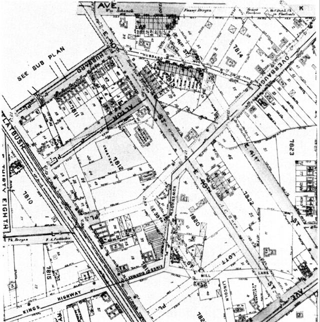
Nieuw Amersfoordt's diverse geography was particularly appealing to early Dutch residents of the area. It's saltwater marshes were familiar landscape to these early settlers, where they grew rich salt marsh hay for cattle, and its fertile plains grew a number of native and imported plants including Tobacco. It's likely that Sagabon (hence the name Sag Harbor), Apios Tuberosa, a native tuber, was grown in these areas before the introduction of the potato. The English generically called all tubers pen (pin, pon or bun), and it is possible that tubers from Lilies also were a source of harvestable food. The large oyster and clam beds were a great natural resource for the early Dutch and made a large part of their diet. The Dutch brought their experience at building Dikes to the New World. This technology, when brought to bear to the marshes of Jamaica Bay enlarged fertile areas to grow crops, particularly around Barren Island, known as 'T Beeren Eylandt, which was a sizable tobacco plantation. Much of the earliest European history of Nieuw Amersfoordt is oral, only indirectly confirmed by official records. It's likely that the town was settled as early as 1623 by French Walloons who escaped puritan oppression in Dutch held lands. Official history begins in the summer of 1636, when Andreas Hudde (which the Junior High School on Nostrand Ave. and Ave. K is named after, and which was visited by President Clinton in 1998) Wolfert Gerretsen ( Van Kouwenhoven), as in the community called Gerretsen Beach, and Wouter Van Twiller, then Governor, bought over 15,000 acres of land for farming. The little settlement that grew up around them became Nieuw Amersfoordt. This town eventually centered near today's junction of Kings Highway and Flatbush Ave., known as the Flatlands Town Center. In 1664, the town was officially given a charter as the town of Flatlands. The Flatlands Dutch Reform Church was built at this location, where it is still located. In 1794, the town had only 48 families, 423 people, one third of whom were black slaves. Slavery in Flatlands lasted longer than most of the rest of New York because of the number of farms in the area. In fact, during the battle of Brooklyn, English soldiers had trouble getting information from the Dutch because the slaves they most often ran into spoke only Dutch. All the original roads that made Flatlands Center are now gone, and to a large degree, the landscape has been entirely altered. As an example of the severity of the change in landscape, the Wykoff House, originally build in 1652 on a hill that over looked most of the possessions of the family, now stands firmly in a depression. That is, all of them are gone except for on, Hubbard Lane, a shortcut between Flatbush Ave. to Flatlands Neck Road. Half of that country lane miraculously survives as Hubbard Place. To walk its path, one finds himself sliding into history, feeling the presence of the Reform Church in the background, it is only about 25 feet wide, and certain parts of it have no sidewalk. The lane itself, located just south of Ave. K and Kings Highway, was named for Revolutionary War patriot, Elias Hubbard. Their family was evidently influential in Flatlands even into this century as they donated the Amersfoordt Park on Avenue J and 38th Street. It was rebuilt with the help of the Dutch Government and was a generous donation to an area short on park land or play grounds. Hubbard had 75. In addition to Hubbard, other families on the lane included Ulpianus Van Sinderen, Folkert Sprong, Aaron Van Pelt, Reverend Ulpianus Van Sinderen, who lives on the south side of the park. The Reverend served in a rotation, preaching in most of Kings County until he retired and his house survived until the 1920's. Van Pelt was the town Constable in 1783, and was a fisherman. Van Pelt is also important because his house survived to this day. There is no sidewalk in front of the home, and is the only house to survive this time period on the lane. Built in 1790, it currently sits vacant, with a legal notice of eviction on it (April 1998). It's future status is a question. What makes Hubbard Lane and Flatlands unique is that it was largely self-sufficient until the early 1800's. By 1840, the population grew to about 800. The rate of growth when compared to the county being very slow. Life centered around the farm with little outside influence, though these residents had the advantage of being in contact with Brooklyn and New York. Baxter, for example, describes going to Brooklyn to see the interment of the Bones of those who died on the British Prison Ships during the revolution. In 1827, New York State declared emancipation of all slaves. In 1820, Flatlands had 107 slaves out of 512 residents. Through the 1830's and 1840's, black laborers were still common in Flatlands, though most slaves left to pursue agricultural work with other farms, or different means of support. In the Dutch system of slavery, blacks were allowed to buy their freedom and were often paid. The details of the treatment of Black slaves will hopefully come to light with the coming excavation of the old slave quarters at the Lott House. But one can assume that many of the freed slaves went on to urban areas like Brooklyn, where the local papers complained in the mid 1820's that "The Outcasts and indigent sons of Africa" would sell oysters and clams, and then spend the proceeds on liquor on Sundays and get drunk. Brooklyn had more free Blacks than slaves. In 1820 it had 657 Free Negroes and 190 slaves. As late as 1872, the Flatlands Town directory showed of 87 people listed, 49 were farmers and six were employed on the waterfront in the fishing industry. By this time, Flatlands also had a number of blacksmiths, wheelwrights and storekeepers, as was needed as the farms lost there slaves. These businesses existed around the town center nearby Hubbard lane. The country store owned by JB Henndickson & Son survived until Kings High Way was completely redrawn and widened. In 1848, a new church was built, the current structure and in 1850, a Methodist Congregation began. New houses built in the late 1800's started to eat away at the farms on Hubbard Lane. Today, there is one surviving specimen, the Williamson House, with an interesting border along an alleyway which was likely originally part of Flatlands Turnpike.


Even still, if one walks up Hubbard Lane and through the streets of Flatlands, south and around, one feels the closeness of the original town center.
The old Ghost of Flatlands still haunt us!! |